Site Investigation


When carrying out any geotechnical work, the initial investigation work is vital. Site investigations for geotechnical work or foundations require a thorough knowledge of past land use and the insitu and disturbed geology. We prefer to carry out all our own site investigations, only employing specialists to carry out the actual boring and laboratory work under our direct supervision. That way we can be sure of collecting the correct information we need to design the proposed works in the most efficient manner.
Before going to site, a desk study is carried out, this is often the most important part of any site investigation. Topographic ground model data and maps can be handled in digital form to build up an accurate 3D model of the ground surface. Aerial photographs are viewed on stereo equipment to examine the area for features which may not be easily seen or recognised from the ground. A comprehensive database of previous investigations, old maps and geological memoirs is kept, to ascertain as much information about the site as possible, so that the later stages of investigation can be properly planned.
Once the background information has been gathered, a walkover survey of the site and the surrounding area is undertaken. Attention is paid to the geomorphology of the area, any clues to the underlying geology are examined. All surrounding buildings and structures are examined for signs of distress or instability.
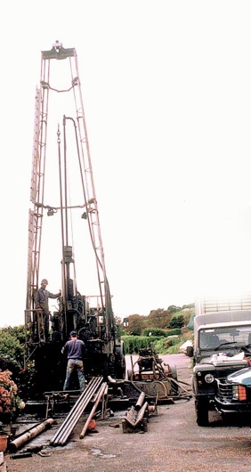
Only then can the appropriate type, depth and equipment for the below ground investigation be nominated. This may range from simple trial pits, percussion boring from a tripod rig, rotary boring, or the use of a combined rotary/percussion rig. The information from the borings can be supplemented by insitu testing, using a lightweight dynamic penetration testing rig or, in soft soils, penetration vane testing or sounding with the Dutch Cone apparatus.
During the borehole investigation, instrumentation may be installed in the boreholes. Either standpipe or vibrating wire piezometers are used to measure the pore water pressure. Inclinometer tubing is installed where ground movement may be expected.
All samples recovered are inspected back at the laboratory, photographed and described in detail. An appropriate schedule of testing is devised to give the information required for the design of a particular scheme.
Investigations that we have carried out have been responsible for correcting the published geology of Ventnor, Seaview and West Cowes.